deutsch englisch spanisch französisch italienisch
Part of Tabula Peutingeriana - Rome

Tabula Peutingeriana – Single display of hits

Toponym TP (renewed):

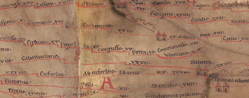
Petra

Name (modern):

Gimir

Image:
To the image detail
Toponym before XV     Congusso     
Toponym following XX     Comitanasso     
Alternative Image ---
Image (Barrington)
Area:

Asia Minor

Toponym Type:

Toponym, no Symbol

Grid square:

9B1

Toponym Color:

black

Vignette Type :

---

Itinerary:


Alternative Name (Lexica):


Name A (RE):

Perta 2

Name B (Barrington Atlas):

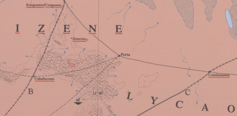
Perta (63 C4)

Name C (TIR/TIB/others):

Perta (TIB 4, 213)

Name D (Miller):

Petra

Name E (Levi):


Name F (Ravennate):


Name G (Ptolemy):

Πέρτα (5,4,10)

Plinius:


Strabo:


Dating from Toponym on TP:

Roman Imperial Period (2nd century)

Argument for Dating:

Der Name ist in der Literatur von Ptol. bis ins 12. Jh. n. Chr. überliefert.

Commentary on the Toponym:

Namensform (verschrieben) nur hier überliefert.
Der Name ist keltisch oder lykisch (s. Zgusta 1984, 486f; Lit. s. Falileyev 2007, 165)

Korrekte Namensform:
- Πέρτα Ptol. 5,4,10 Λαοδίκεια κατακεκαυμένη - Οὐάσαδα (Οὐάσατα) – Πέρτα, Ort in Südpaphlagonien oder Lykaonien, im Gebiet der Obizener; Notit. Episc. 1,369 Darrouzès u. ö. (weitere Stellen s. TIB 213)
- Ethnoym Gen. Pl. Περτηνῶν MAMA VIII 263 und Περτέων MAMA VIII 270.

Weitere Verschreibung:
- Πτέρνα Hierokl. synekd. 676,3 Ort der Eparchie Lykaonia unter der Metropolis Ikonion

Stadt am nördöstl. Fuße des Ballık Dağ, 12,5 km westl. des Obruk Han und in Wirklichkeit 58 km nordöstl. von Ikonion (9B2 yconio). Laut TP Station an der nördlichen Diagonalverbindung durch Lykaonien von Amorion (8B4 Amurio) bzw. 8B4/5 Abrostola nach 9B1 Salberina (s. TP; zur Straßenlinie s. u.), bzw. in mittelbyzantin. Zeit an der nördl. Route von der Kilikischen Pforte nach Amorion (Ibn Hurdadbih).

Die Kulte für Zeus und Apollon bezeugen auch in röm. Zeit noch starke griech. Einflüsse (s. Breytenbach 2018, 223).

Als Bistum durchgängig bezeugt vom Konzil von Konstantinopel 381 bis ins 12. Jh. (s. TIB 4, 213 mit Belegen). Zum frühen Christentum in Perta s. Breytenbach 2018.

Die Lage für den Siedlungshügel unmittelbar östl. von Gimir (ehem. Hirbat bzw. Qukaryat Farita) ist durch Inschriftenfunde (s. o.) bestätigt, wo reichlich antike und byzantin. Spolien und Inschriften vorhanden sind. Auch in der Umgebung zahlreiche Inschriftenfunde (s. TIB 213 mit Lit.).

Die Kulte für Zeus und Apollon weisen auch in röm. Zeit noch starke griech. Einflüsse auf (s. Breytenbach 2018, 223).

Als Bistum durchgängig bezeugt vom Konzil von Konstantinopel 381 bis ins 12. Jh. (s. TIB 4, 213 mit Belegen). Zum frühen Christentum in Perta s. Breytenbach 2018.


Meilenangabe nach Comitanasso: XX (20)
Hinter Perta verlief die Route in Wirklichkeit in Richtung Osten. Der Kartograph trug jedoch das Toponym der Folgestation Comitanasso über statt vor der danach folgenden Station Vbinacca ein; darunter zeigt die Straßenlinie eine leichte Einbuchtung. Anscheinend hat sich der Kartographie mit der Länge der Strecke verschätzt, und nachdem er gemerkt hatte, das der Platz nicht ausreichte, die Stationennamen über- statt hintereinander eingetragen. Dies zeigt, dass er hier recht kleinteilig „auf kurze Sicht“ gearbeitet hat und die Streckenführung nicht im Hinblick auf ein größeres Gesamtkonzept geplant hat.
Talbert kommentiert: „Even though the space is available, there is no attempt here to repeat the expedient of a reverse turn used for the approach to Sinope from Thomia and Syrtad above (9A1)“ (https://www.cambridge.org/us/talbert/talbertdatabase/TPPlace2316.html).


Kommentar (Talbert):
After Petra, the route curves up and the mapmaker has two stretches to fit in before the junction at Salaberina, although only space for one name and distance figure. Having begun the first name (Comitanasso), he therefore then makes it slope away and above the second name. Route linework follows only under the second name (Vbinnaca). Even though the space is available, there is no attempt here to repeat the expedient of a reverse turn used for the approach to Sinope from Thomia and Syrtad above (9A1).

Miller, Itineraria, Sp. 690:
Petra (Irrig Potra (Ve), Pterna (Hl), Perta – Πέρτα (Pt), ὁ Πέρτων (ne); j. Ruinen.

References:

Ballance, M. H.: Roman Roads in Lycaonia, Anatolian Studies 8 (1958), 223-234, hier: 224-228.

Breytenbach, Cilliers: Early Christianity in Lycaonia and adjacent areas: from Paul to Amphilochius of Iconium, Leiden – Boston 2018, 222-236.

Εγκυκλοπαίδεια Μείζονος Ελληνισμού, Μ. Ασία
http://asiaminor.ehw.gr/Forms/fLemmaBody.aspx?lemmaid=12346

Falileyev, Alexander: Dictionary of Continental Celtic Place-Names, Aberystwyth University © 2007, 165.

Hild, Friedrich: Das byzantinische Straßensystem in Kappadokien (= Denkschriften philosophisch-historischen Klasse 131), Wien 1977, 61f.

Miller, Itineraria, Sp. 690.

Ruge, W.: Perta 2, RE 19,1 (1937), 1058f.

Zgusta, Ladislav: Kleinasiatische Ortsnamen, Heidelberg 1984, 486f.

   [Standard-Literatur-Liste im PDF-Format]

Last Update:

18.12.2022 10:57


Cite this page:
https://www1.ku.de/ggf/ag/tabula_peutingeriana/trefferanzeige_en.php?id=1430 [last accessed on September 27, 2024]

Edition Information Privacy Statement