deutsch englisch spanisch französisch italienisch
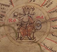
Part of Tabula Peutingeriana - Rome

Tabula Peutingeriana – Single display of hits

Toponym TP (renewed):

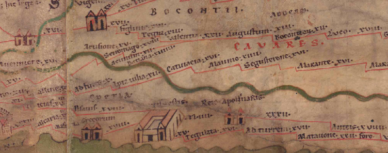
Catuiacia

Name (modern):

(near Céreste) (Barrington)

Image:
To the image detail
Toponym before XII     Aptaiulia (Apta Iulia)     
Toponym following XVI     Alaunio     
Alternative Image ---
Image (Barrington 2000)
Image (Scheyb 1753) ---
Image (Welser 1598) ---
Image (MSI 2025) ---
Area:

Gaul/Germania

Toponym Type:

Toponym, no Symbol

Grid square:

2B1

Toponym Color:

black

Vignette Type :

---

Itinerary:

Catuiaca (343,2)

Alternative Name (Lexica):


Name A (RE):

Catuiacia

Name B (Barrington Atlas):

Catuiacia (15 F2)

Name C (TIR/TIB/others):


Name D (Miller):

Catuiacia

Name E (Levi):


Name F (Ravennate):


Name G (Ptolemy):


Plinius:


Strabo:


Dating from Toponym on TP:

---

Argument for Dating:


Commentary on the Toponym:

Miller, Itineraria, Sp. 134:
Catuiacia, it. (IG 2.3), Catuiaca (It), Catuiaciam (IG 1); j. wohl Cereste; nach anderen Carlue; s. Papon, Hist. Prov. I S. 66. Henry, Rech. s. l. géogr. ancienne du dép. des Basses Alpes, S. 141/2 und Karte. M. Long, Ant. Romain. du pays des Vocontiens S. 450. Iss : 1126. 1138. 1140.
Zur Strecke Alaunio Vapincum vgl. CIL XII p. 184.
16, it. (It, IG 1.2.3).

Datierung (Barrington):
Catuiacia - Roman/Late Antique (Barruol 1962, 166-69).

RE
Catuiacia
RE Ihm III,2 1795 — Catuiacia, Station in Gallia Narbonensis zwischen Segustero (Sisteron) und Apta Iulia (Apt), CIL XI 3281–3284 (einmal Catulacia). Tab. Peut. Itin. Ant. 343 Catuiaca, Var. Catuluca u. a. Desjardins Table de Peut. 60. [Ihm.]


"TP-Online-ID: 3247 — Catuiacia

Desjardins S. 60.

Lesung und Namensform bei Desjardins: Catuiacia; normalisierte Form: CATUIACIA.

Lage und Route bei Desjardins: Region/Lage: Narbonensis II. Typ: Station. Route/Abschnitt: LXXIII. d’Arelato, ARLES, à In Alpe Cottia, MONT-GENÈVRE.

Quellenstellen bei Desjardins: It. Ant. 343,2: Catuiaca; CIL XI 3281–3284: CATVIACIAM/CATVIACIA.

Moderne Identifikation bei Desjardins: Unsicher: Carluc zwischen Reillane und Céreste; außerdem Céreste, Oppedette, Forcalquier, Les Roquettes oder Reillane.

Kommentar und Forschungsstand bei Desjardins: Desjardins stellt zahlreiche Lokalisierungen zusammen. Papon, Henry und Long setzen die Station bei Carluc zwischen Reillane und Céreste, wo die Distanzen passen und antike Reste vorhanden seien; andere Autoren schlagen Céreste, Oppedette, Forcalquier, Les Roquettes oder Reillane vor.

Zusatz aus Desjardins’ Gallien-/Germanienanalyse (S. 72 und 77): In der systematischen Einzelprüfung der Narbonensis führt Desjardins diesen Namen unter den Ortsnamen, die er ausdrücklich als sicher vor dem Tod des Augustus bzw. spätestens augusteisch einstuft.

Bearbeitungshinweis: Typ ausdrücklich Station; keine eindeutige eigene Lokalisierungsentscheidung vortäuschen."

References:

Desjardins, Table, p. 60, col. 1, no. 4.

Miller, Itineraria, Sp. 134.

Ihm, Maximilian, Catuiacia, in: RE III/2 (1899), Sp. 1795.

   [Standard-Literatur-Liste im PDF-Format]

Last Update:

25.08.2026 11:46


Cite this page:
https://www1.ku.de/ggf/ag/tabula_peutingeriana/trefferanzeige_en.php?id=3247 [last accessed on September 6, 2026]

Edition Information Privacy Statement