deutsch englisch spanisch französisch italienisch
Ausschnitt aus der Tabula Peutingeriana - Rom

Tabula Peutingeriana – Pantalla individual
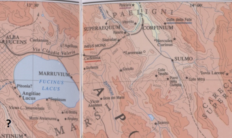
Topónimo (simplificado):

Statule

Nombre (moderno):

westlich von Goriano Sicoli [3]

Imagen:
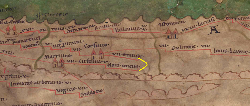
Al detalle de la imagen
Topónimo antes VII     Corfinio     
Topónimo después -     Mons Imeus     
Imagen alternativa
Imagen (Barrington 2000)
Imagen (Scheyb 1753) ---
Imagen (Welser 1598) ---
Imagen (MSI 2025) ---
Pleiades: https://pleiades.stoa.org/places/413322
Área:

Italia

Tipo de topónimo:

Topónimo sin símbolo

Cuadrícula:

5B2

Color del topónimo:

negro

Tipo de viñeta:

---

Itinerario:


Nombres alternativos (diccionarios):


Nombre A (RE):

Statulae - https://elexikon.ch/RE/IIIA,2_2233.png

Nombre B (Barrington Atlas):

Statulae (42 F4)

Nombre C (TIR / TIB /otros):


Nombre D (Miller):

Statule

Nombre E (Levi):


Nombre F (Ravenate):


Nombre G (Ptolemaios):


Plinius:


Strabo:


Datación del topónimo en la TP:

indeterminado hasta ahora

Fundamento para la datación:

Fehlende literarische oder epigraphische Belege.

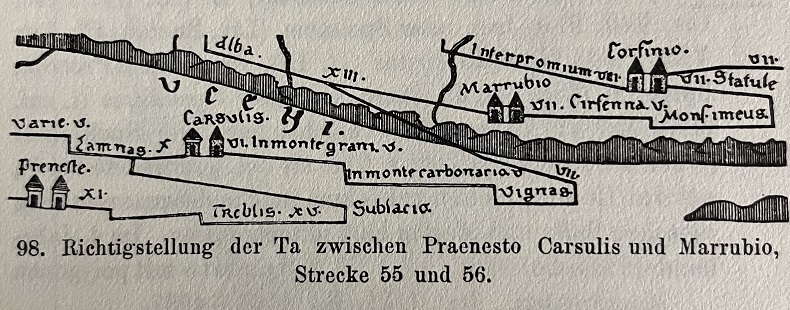
Comentario al topónimo:

[PK: warum endet die Strecke im Nichts mit einem Haken, eigentlich müsste es weiter gehen nach Mons imeus laut BAtlas].
Es würde Sinn ergeben, die Strecke nach Statule zu verbinden, laut Itinerar führt die Strecke dann nach Hadria (cf. It 310,1).

Kommentar (Talbert):
The map as we have it represents Statvle as a deadend, and Mons imevs below likewise. It is tempting to think (with ItMiller 323), however, that a link between them made by the mapmaker has been omitted by copyists (along with a distance figure, presumably); compare BAtlas 44 E1. There is no knowing where the link would have been placed (perhaps a vertical line running between Mons and imevs ? Compare the linkage of Ad Rotas and Adflexvm in 5B3). In any event, this section of the map illustrates the difficulties that its design creates for presenting a route vertically rather than horizontally. Moreover when Corfinio and Marrvbio are not far apart on the map, the need to establish route stretches for each of the three intermediate stations poses an additional problem.

Miller, Itineraria, Sp. 323:
Statule; j. westlich von Goriano Sicoli. Bei La Statura römische Reste. Hier wurde 1903 1 Meilenstein von Magnentius gefunden, 90 mp von Rom. 7.

Datierung (Barrington):
Statulae – Hellenistic/Roman (FormIt Superaequum 39)

RE:
Statulae, Station der Tabula Peutingeriana im Lande der Paeligner, 7 römische Meilen von Corfinium, ist durch de Nino (Not. s. scav. 1889, 344) in La Statura, westlich von Goriano Siculi, südwestlich von Corfinium nachgewiesen; daselbst römische Reste. 1903 fand sich dort ein Meilenstein des Kaisers Magnentius, 90 römische Meilen Rom. Vgl. Miller Itin. Rom. 323. [Philipp].

Bibliografía:

[1] Cuntz, Topographische Studien

[2] Desjardins, Table, p. 170, col. 1, no. 12.

[3] Miller, Itineraria, Sp. 323.

[4] Philipp, Hans, Statulae, in: RE III. A2 (1929), Sp. 2233.

______________
FormIt Superaequum 39)

   [Standard-Literatur-Liste im PDF-Format]

Última elaboración:

26.10.2025 19:03


Cite this page:
https://www1.ku.de/ggf/ag/tabula_peutingeriana/trefferanzeige_es.php?id=333 [zuletzt aufgerufen am 14.11.2025]

Derechos Política de privacidad