deutsch englisch spanisch französisch italienisch
Ausschnitt aus der Tabula Peutingeriana - Rom

Tabula Peutingeriana – Pantalla individual

Topónimo (simplificado):

[Nesatio]/Pola

Nombre (moderno):

Vizače (Barrington)

Imagen:
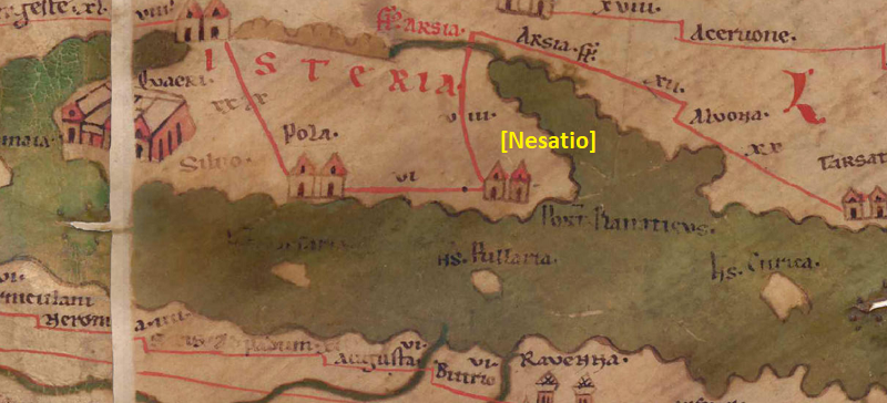
Al detalle de la imagen
Topónimo antes VI     Pola     
Topónimo después VIII     Arsia Fluvius     
Imagen alternativa ---
Imagen (Barrington 2000) ---
Imagen (Scheyb 1753) ---
Imagen (Welser 1598) ---
Imagen (MSI 2025) ---
Área:

Italia

Tipo de topónimo:

Símbolo sin nombre

Cuadrícula:

4B1

Color del topónimo:

sin color

Tipo de viñeta:

A Torre doble

Itinerario:


Nombres alternativos (diccionarios):


Nombre A (RE):

Nesactium

Nombre B (Barrington Atlas):

Nesactium (20 A5)

Nombre C (TIR / TIB /otros):


Nombre D (Miller):

[Nesatio]

Nombre E (Levi):

Portus Flanaticus (A,II,1)

Nombre F (Ravenate):

Nessatio (p. 68.13), Nesatium (p. 95.25)

Nombre G (Ptolemaios):

Νέσακτον τέλος Ἰταλίας (3,1,27)

Plinius:

oppidum Nesactium (3,129; 3,140)

Strabo:


Datación del topónimo en la TP:

---

Fundamento para la datación:


Comentario al topónimo:

Es handelt sich wohl in Wirklichkeit um Pola an der Südspitze Istriens, das durch den Fehler eines Zeichners/Kopisten auf der TP an die Stelle von Parentium verschoben erscheint (s. Degrassi 1939, 65f und Bosio 1974; vgl. dazu Art. Pola und Isteria).

Weniger wahrscheinlich ist gemeint (vgl. BAtlas 20A5; TIR L 33, 54), heute: Vizače (Theorie von Fluss RE 65; Vedaldi-Iasbez 1994, 364). Nesactium, 177 v. Chr. von den Römern erobert (Liv. 41,11,1), war ein wichtiges Zentrum (municipium) nahe der Südspitze der Halbinsel mit Thermen und Nekropole (TIR) an der Küstenstraße, die Pola mit Tarsatica verband (vgl. Liv. 41,11,1 Nesactium [so Briscoe mit Cluuerius; Etmattius V]; Plin. nat. 3,129; Ptol. 3,1,27; Rav 4,31 p. 68,13 Nessatio; Rav 5,14 p. 95,25 Nesatium; Guido 20 Nissacium; Guido 116 Nesacium; die antiken Erwähnungen des Ortes sind gesammelt und besprochen bei Vedaldi-Iasbez 1994, 360-364; zur Lokalisierung s. d. mit weiterer Literatur). Wahrscheinlicher ist, daß auf der TP Nesactium vergessen wurde und daß sich die Meilenangabe VI von dem in seiner Position verrutschten Pola noch auf diesen ausgelassenen Ort bezieht (s. ItMiller 313), wobei die tatsächliche Distanz zwischen Pola und Nesactium ca. 9 Meilen beträgt.

Noch weniger wahrscheinlich ist (vgl. BAtlas 20B4; TIR L 33, 38, heute: Plomin), s. dazu Art. Portus Flanaticus. Denn Flanona liegt in Wirklichkeit an der Ostküste Istriens und daher auf der TP weiter oben eingetragen sein (s. Degrassi 1939, 66).

Miller, Itineraria, Sp. 313:
6 - die Zahl kann sich nur beziehen auf das fehlende: [Nesatio], beim Ra Nesatium, Nesactium, (Pt, Pl), Nesattium (Liv), Nessatio (Ra), Nesacium und Nissacium (Gu), Nesacton (Pt), Nesaction (Pl); j. bei Altura und Umgegend, wo Iss in Barbana, Momorano, Altura: CIL V 1-5. Suppl. I 1-5.

Datierung (Barrington):
Nesactium - Hellenistic, Roman, Late Antique (Mihovilić 1984; Zaninović 1994; Vedaldi
Iasbez 1994, 360-64).

PK: Vorsicht, Levi ordnet dieser namenlosen Vignette fälschlicherweise "Portus Flanaticus" zu.

RE (wenn man hier Nesactium annimmt):
https://elexikon.ch/RE/XVII,1_65.png

Nesactium Smith:
NESACTIUM (Νεσάκτον, Ptol.), a town of Istria, situated to the E. of Pola, on the Flanaticus Sinus, and not far from the river Arsia, which was the boundary of Istria on this side. Hence Ptolemy calls it the last city of Italy. It is mentioned by Livy as a city. of the Istrians before their conquest by Rome, and a strong fortress, so that it stood a long siege, and was only taken by the Roman consul C. Claudius Puleher, by cutting off its supply of water (Liv. 41.11). It afterwards appears both in Pliny and Ptolemy as a municipal town of Istria under the Romans, and seems to have survived the fall of the Western Empire, but the period of its destruction is unknown (Plin. Nat. 3.19. s. 23; Ptol. 3.1.27; Tab. Peut.; Anon. Rav. 4.31). The fact of its proximity to the Arsia (Arsa), combined with Livy`s mention of a river flowing by the walls, render it probable that it was situated immediately on the right bank of the Arsia; but its exact site has not been determined.

Bibliografía:

Bosio, Luciano: L´Istria nella descrizione della Tabula Peutingeriana, Trieste 1974, 63-67.

Degrassi, Nevio: La rappresentazione dell´Istria nella Tabula Peutingeriana, Bollettino Del Museo Dell´impero Romano 10 (1939), 65-68, hier: 65f.

Fluss, Max, Nesactium, in: RE 17.1 (1936), Sp. 65-68.

Miller, Itineraria, Sp. 313.

   [Standard-Literatur-Liste im PDF-Format]

Última elaboración:

30.10.2025 08:24


Cite this page:
https://www1.ku.de/ggf/ag/tabula_peutingeriana/trefferanzeige_es.php?id=671 [zuletzt aufgerufen am 14.11.2025]

Derechos Política de privacidad