
Tabula Peutingeriana – Einzelanzeige
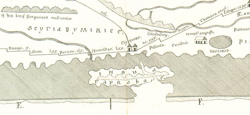
| Toponym TP (aufgelöst): | Insula Taprobane |
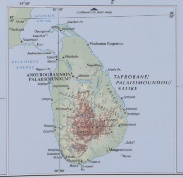
| Name (modern): | Sri Lanka |
| Bild: | 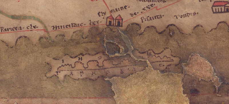 Zum Bildausschnitt auf der gesamten TP |
| Toponym vorher | |
| Toponym nachher | |
| Alternatives Bild |
 |
| Bild (Barrington 2000) |
 |
| Bild (Scheyb 1753) | --- |
| Bild (Welser 1598) | --- |
| Bild (MSI 2025) | --- |
| Pleiades: | https://pleiades.stoa.org/places/50298 |
| Großraum: | Indien |
| Toponym Typus: | Insel |
| Planquadrat: | 11C4 / 11C5 |
| Farbe des Toponyms: | schwarz |
| Vignette Typus : | --- |
| Itinerar (ed. Cuntz): |
|
| Alternativer Name (Lexika): |
|
| RE: | Tapronane - https://elexikon.ch/RE/IVA,2_2261.png |
| Barrington Atlas: | Taprobane/Palaisimoundou/Salike Ins. (5 inset) |
| TIR / TIB /sonstiges: |
|
| Miller: | Insula Taprobane |
| Levi: |
|
| Ravennat: | Taprobane (p. 17.52; 104.41) |
| Ptolemaios (ed. Stückelberger / Grasshoff): |
|
| Plinius: |
|
| Strabo: |
|
| Autor (Hellenismus / Späte Republik): |
|
| Datierung des Toponyms auf der TP: | Frühhellenismus (vor 200) |
| Begründung zur Datierung: | Die älteste Beschreibung von Taprobane bietet Eratosthenes (Strab. 15,1,14 C 690), der sich Megasthenes und Daimachos stützt. Da die Tabula Peutingeriana außer der Darstellung der Insel selbst zu Taprobane keinerlei Informationen (Toponyme, Ethnonyme usw.) bietet (noch nicht einmal Mantai als einer der wichtigsten kaiserzeitlichen Warenumschlagplätzen ist eingetragen) dürfte sich hier das recht vage Wissen der hellenistischen oder der frühen Kaiserzeit widerspiegeln. |
| Kommentar zum Toponym: |
Kommentar (Talbert): |
| Literatur: |
Miller, Itineraria, Sp.851f.; Don P.M. Weerakkody, Taprobane. Ancient Sri Lanka as known to Greeks and Romans, Turnhout 1997, 17-25. 99-104; Stefan Falter, Taprobane im Wandel der Zeit. Das Śrî-Laṅkâ-Bild in griechischen und lateinischen Quellen zwischen Alexanderzug und Spätantike, Stuttgart 2000 (= Geographica historica 14), 174f.; Steven E. Sidebotham, Roman Economic Policy in the Erythra Thalassa. 30 B.C.-A.D. 217, Leiden 1986 (= Mnemosyne 91), 32f.; Klaus Geus, Eratosthenes in: Wolfgang Hübner/GermaineAujac (Hrg.), Geographie und verwandte Wissenschaften, Stuttgart 2000 (= Geschichte der Mathematik und der Naturwissenschaften 2), 75-92, hier 91; Klaus Karttunen, in: DNP 12 / 1, 2002, 18-19 s.v. Taprobane; Reinhold Walburg, in: DNP 15 / 3, 2003, 251-253 s.v. Sri Lanka; Klaus Geus, Die Geographika des Eratosthenes von Kyrene: Altes und Neues in Terminologie und Methode, in: Michael Rathmann (Hrg.), Wahrnehmung und Erfassung geographischer Räume in der Antike, Mainz 2007, 111-122, hier 121; Steven E. Sidebotham, Berenike and the Ancient Maritime Spice Route, Berkeley/Los Angeles 2011, 192f.; Omar Coloru, Taprobane. in: Roger S. Bagnall/Kai Brodersen/Craige B. Champion/Andrew Erskine/Sabine R. Huebner (Hrg.), The Encyclopedia of Ancient History 11, 2013, 6528. |
| Letzte Bearbeitung: | 18.06.2026 14:05 |
Cite this page:
https://www1.ku.de/ggf/ag/tabula_peutingeriana/einzelanzeige.php?id=2471 [zuletzt aufgerufen am 10.07.2026]