deutsch englisch spanisch französisch italienisch
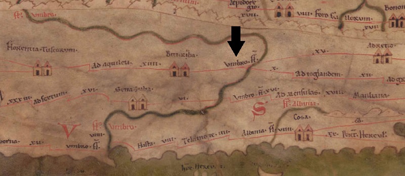
Ausschnitt aus der Tabula Peutingeriana - Rom

Tabula Peutingeriana – Einzelanzeige

Toponym TP (aufgelöst):

Vmbro Flumen (Umbro Flumen)

Name (modern):

Pogi / Pieve di Capannole (Bucine) (TIR)

Bild:
Zum Bildausschnitt auf der gesamten TP
Toponym vorher -     Bituriza     
Toponym nachher XV     Adretio     X     Ad Ioglandem     
Alternatives Bild ---
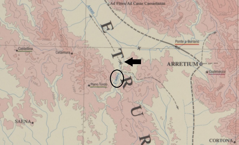
Bild (Barrington)
Großraum:

Italien

Toponym Typus:

Ortsname ohne Symbol

Planquadrat:

3B3 / 3B4

Farbe des Toponyms:

schwarz

Vignette Typus :

---

Itinerar (ed. Cuntz):


Alternativer Name (Lexika):


RE:


Barrington Atlas:

*Umbro fl. (42 B2)

TIR / TIB /sonstiges:

Umbro fl. (TIR K 32, 184, 909), Umbro fl. (TIR K 32, 183f., 908)

Miller:

Vmbro fl.

Levi:


Ravennat:

Umbrion (p. 74.32)

Ptolemaios (ed. Stückelberger / Grasshoff):


Plinius:


Strabo:


Datierung des Toponyms auf der TP:

---

Begründung zur Datierung:


Kommentar zum Toponym:

Kommentar Köhner:
Es handelt sich hierbei entweder um die Brücke über den Ambra, der auf der TP mit dem Umbro zusammenkompiliert wurde. (Siehe TIR, Talbert und Miller) oder doch um eine Straßenstation siehe TIR Umbro 908.

Frage zu den Distanzangaben, was passiert, wenn man die Distanzen von Adretio XV bis Bituriza annimmt und X von Ioglandem nach Bituriza? Also dass die Brücke über den Umbro gar keine Station ist, sondern als solche uminterpretiert wurde (ohne Distanzangaben?)

Kommentar (Talbert):
ItMiller 289 wants the name to refer, not to a route station, but to the river (#24), even though (as he realizes) it is written in black ink, not red; he believes the figures XV and X following Vmbro Fl. to be distances from Bitvriza, therefore. I hesitate to concur on either count. The river name is given, as usual, at its source; unusually, it is also repeated near the mouth, but that may be because the copyist visibly redrew its course there, and wished to confirm the name. For a river name also to be repeated halfway along its course is not the map`s regular practice. A further cause of confusion must be that copyists, if not even the mapmaker too, failed to realize that there are two rivers called Vmbro, one a tributary of the Arnvs, the other flowing into the Tyrrhenian Sea: see BAtlas 42 A3 and B2.

There is no chicane to mark the start of the stretch, only the fork in the route.

Miller, Itineraria, Sp. 289:
[Vmbro fl., Umbrion (Ra), Umbrium und Umbrona (Gu), ist nicht als Station aufzufassen, sondern sollte als Fluß, j. Ambra, rot geschrieben sein.] 15 (Fehlt bei Bt, Bg, Ve).

Datierung (Barrington):
*Umbro fl. – ? (ItMiller 289)

Ambra (Miller/Barrington)

TIR
UMBROFL. 908
Pieve di Capannole (Bucine)
I, Toscana, Arezzo VII
Mansio/statio XII/b
a. Stazione viaria in Tab. Peut. a XV miglia da Arezzo presso il congiungimento della strada per BITURGIA e la VIA CASSIA da AD JOGLANDEM (Pieve di Capànnole, Tracchi), da cui dista X miglia, in corrispondenza dell`UMBRO FL. (= fiume Ambra: resti di un ponte romano (?) con rifacimenti medievale, cfr. Mosca 1995, p. 56, n. 19). Vicino alla strada statale, tegole, coppi, altri frammenti di laterizi, e un ripostiglio di monete imperiali. Resti di ponte romano a più arcate sulla Trove in località Mulino al Suono, da cui si poteva proseguire per Pogi e SELVAPIANA (Mosca 1995, p. 60, n. 25). Sulla strada UMBRO FL. - Arezzo in Tab. Peut., resti di piccoli insediamenti romani (presso Villa Pancona e verso nord, in località Paretaino). Sulla riva ovest dell`Ambra, resti di costruzioni romane in reticolato con ammorsature laterizie in localtà Roma Vecchia, su una strada forse corrispondente a quella antica per Selva e il Senese (Tracchi).
c. Tab. Peut. IV,4; Rav. IV,36; Guido 52.
e. Ponte. Resti non identificabile. Insediamento.
f. Miller 1916, pp. 289 e LII; Lopes Pegna 1971a, p. 12; Tracchi 1978, pp. 66-67, 136-137; Degrassi 1984-85, pp. 183-185; Bosio 1986, pp. 454-467; Galliazzo 1994-1995, II, p. 175, n. 379.


TIR
UMBRO FL. 909
Pogi
I, Toscana, Arezzo VII
Ponte XII/b
a. Sul percorso della Via Cassia in Tab. Peut. Resti di ponte romano sull`Ambra incorporati in quello medioevale. Sulla riva destra del fiume, in Iocalità Podere Iesolana, tombe romane (insediamento?). Sulla riva sinistra, invece, resti di un piccolo insediamento in Iocalità La Fornace.
c. Tab. Peut. IV, 4; Rav. IV, 36; Guido 52.
e. Necropoli. Insediamento.
f. Tracchi I 978, p. 65; Mosca 1995, p. 56, n. 20.

Literatur:

Miller, Itineraria, Sp. 289. 296;

Umbro fl. (TIR K 32, 183f., 908)
Umbro fl. (TIR K 32, 184, 909)

   [Standard-Literatur-Liste im PDF-Format]

Letzte Bearbeitung:

04.09.2024 14:28


Cite this page:
https://www1.ku.de/ggf/ag/tabula_peutingeriana/trefferanzeige.php?id=103 [zuletzt aufgerufen am 26.11.2024]

Impressum Datenschutzerklärung