deutsch englisch spanisch französisch italienisch
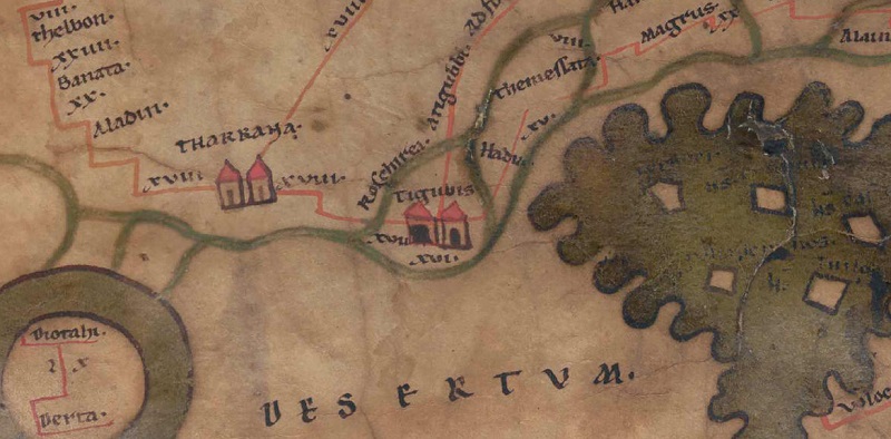
Ausschnitt aus der Tabula Peutingeriana - Rom

Tabula Peutingeriana – Einzelanzeige

Toponym TP (aufgelöst):

Tigubis

Name (modern):


Bild:
Zum Bildausschnitt auf der gesamten TP
Toponym vorher XVII     Roschirea     
Toponym nachher Arigubbi Ad fonte scoborem XVI     Fons Scabore     XVI?     Hadia     
Alternatives Bild ---
Bild (Barrington 2000) ---
Bild (Scheyb 1753) ---
Bild (Welser 1598) ---
Bild (MSI 2025) ---
Großraum:

Asien östl. d. Euphrat, südl. d. Taurus

Toponym Typus:

Ortsname mit Symbol

Planquadrat:

10C3

Farbe des Toponyms:

schwarz

Vignette Typus :

A Doppelturm

Itinerar (ed. Cuntz):


Alternativer Name (Lexika):


RE:

Tigubis

Barrington Atlas:


TIR / TIB /sonstiges:


Miller:

Tigubis

Levi:

Tigubis (A,I,2)

Ravennat:


Ptolemaios (ed. Stückelberger / Grasshoff):

5,17,7

Plinius:


Strabo:


Datierung des Toponyms auf der TP:

---

Begründung zur Datierung:


Kommentar zum Toponym:

Kommentar (Talbert):
-> Stretch to Fons scabore
Along the stretch appears: "Atigvbbi Adfonte scoborem XVI" [e of Adfonte with macron]. Note the lack of concern to spell either placename consistently; compare the upper two stretches from Hierapoli.
River crossing: (river, no. 126c)
-> Stretch to Hadia
It is only conjecture, but surely a reasonable one, that the distance figure XVI below the symbol refers to this stretch. Its placement reflects the difficulty of fitting in all the names and distances hereabouts while keeping lettering clear of rivers. The same difficulty affects the entire route from Tigvbis to Hatris. The result is often clumsy, but it is impressive that the mapmaker marks the number of places he does. The goal of keeping lettering clear of rivers is achieved, except in the case of the final letter of Themessata. Even though the overall result is not without flaws, copyists evidently exercised care in reproducing this part of the map.
River crossing: (river, no. 126d)

Miller, Itineraria, Sp. 778:
Tigubis oder rigubbi (ad fontem scoborem); Thegubris (Ra),
Thergubis (Kp?); j.esSihl, beim 8.Brunnen
von Harran ab.
Abzweigung nach fons Scabore (Strecke 113).
16.

Miller, Itineraria, Sp. 780:
Tigubis, Strecke 112; j . es Sihl.

(SH): Fragezeichen bei der Meilenangabe von Tigubis nach Hadia, da Meilenangabe unter dem Toponym Tigubis steht.

Literatur:

Miller, Itineraria, Sp. 778. 780;

J. Sturm, Tigubis, in: RE VIA1, 1936, 1024.

   [Standard-Literatur-Liste im PDF-Format]

Letzte Bearbeitung:

21.10.2023 11:43


Cite this page:
https://www1.ku.de/ggf/ag/tabula_peutingeriana/trefferanzeige.php?id=1788 [zuletzt aufgerufen am 27.11.2024]

Impressum Datenschutzerklärung