deutsch englisch spanisch französisch italienisch
Part of Tabula Peutingeriana - Rome

Tabula Peutingeriana – Single display of hits

Toponym TP (renewed):

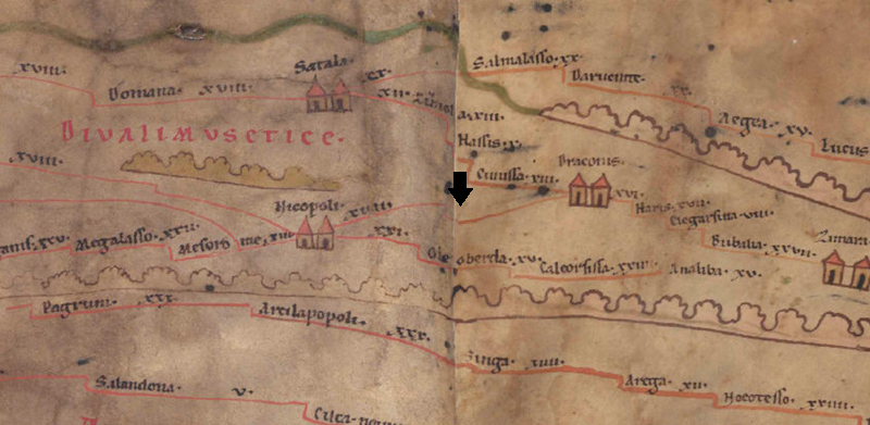
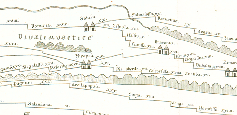
(unnamed / illegible, no. 60)

Name (modern):

? Gölova, ehem. Ağvanis ?

Image:
To the image detail
Toponym before Nicopoli     
Toponym following Draconis     
Alternative Image ---
Image (Barrington) ---
Area:

Asia Minor

Toponym Type:

non-legible Toponym

Grid square:

9A5

Toponym Color:

colourless

Vignette Type :

---

Itinerary:


Alternative Name (Lexica):


Name A (RE):

? Olotoedariza

Name B (Barrington Atlas):


Name C (TIR/TIB/others):


Name D (Miller):

[Olotoedariza]

Name E (Levi):


Name F (Ravennate):


Name G (Ptolemy):


Plinius:


Strabo:


Dating from Toponym on TP:

---

Argument for Dating:


Commentary on the Toponym:

ItMiller 675 vermutet hier den Ausfall von einer oder zwei Stationen, etwa von Olotoedariza (BAtlas 87 D4) bzw. Olotoaelariza, das laut ItAnt 183,2; 207,1 und 215,13 24 Meilen von der vorangehenden Station Nicopolis entfernt war.

Vielleicht identisch mit Aladaleariza (var. lect. ala dade ariza P; ala doleariza V) Notit. Dign. or. 38,17, dem Stützpunkt der Ala Rizena unter dem Dux Armeniae (so richtig ItMiller 679).
“Aladaleariza” wurde möglicherweise verschrieben unter dem Eindruck des vorausgehenden “Ala Rizena”.

Hinter dem Namen steht wohl armen. Olawtadaric o. ä. laut Hewson 2001, 68.

Lokalisierung heute allgemein bei Gölova (ehem. Ağvanis), z. B. Sinclair 1989/90; id. 2019; Mitford 2018 und 2021. In Ağvanis fanden die Gebrüder Cumont 1906 Reste eines Meilensteins (367–375 n. Chr., s. Mitford 2018, vol. 2, 532f Inschrift Nr. 52), auf dem Friedhof Säulenreste und andere bearbeitete Steine. Sinclair sieht darin fast sicher eine röm. Straßenstation, was durch den Fund eines Meilensteines an der Strecke Bestätigung findet.

Eine Identität mit Lytararizon, restauriert von Justinian laut Prok. aedif. 3,4,10, ist unklar (s. Mitford 2018, vol. 2, 533).

Der Ort ist sehr wahrscheinlich nicht identisch mit 9B5/10B1 Oleoberda (s. Artikel dort).


Miller, Itineraria, Sp. 675:
-; ein leerer Haken dazwischen deutet auf das Fehlen von 1 oder 2 Stationen; bis Olotoedariza 24 (bis Draconis 26) (It).

References:

Cumont, F. V. M./Cumont, E.: Voyage d´exploration archéologique dans le Pont et la Petite Arménie (= Studia Pontica 2), Bruxelles 1906, 319.
https://archive.org/details/Travel1900CumontStudiaPontica2.

Hewsen, Robert H.: Maps of Historical Armenia (4th-6th Centuries), in: id.: Armenia: a Historical Atlas, University of Chicago 2001, 64-91, hier: 68f.

Kroll, W.: Olotaedariza, RE 17,2 (1937), 2498.

Miller, Itineraria, Sp. 675.

Mitford, Timothy Bruce: East of Asia Minor: Rome´s Hidden Frontier, Oxford 2018, vol. 1, 293-295; 318 Anm. 21; vol. 2, 532f; 576; Karte 18.

Mitford, Timothy Bruce: Discovering Rome´s Eastern Frontier: On Foot Through a Vanished World, Oxford 2021, 250.

Olshausen, E./Biller, J.: Historisch-geographische Aspekte der Geschichte des Pontischen und Armenischen Reiches. Teil I. Untersuchungen zur historischen Geographie von Pontos unter den Mithridatiden (= TAVO B 29/1), Wiesbaden 1984, 152.

Ramsay, W. M.: A Historical Geography of Asia Minor, London 1890, 56.

Sinclair, T. A.: Eastern Turkey: an architectural and archaeological survey, London 1989-90, vol. 2, 236.

Sinclair, T. A.: Eastern trade and the Mediterranean in the Middle Ages: Pegolotti´s Ayas-Tabriz itinerary and its commercial context (= Birmingham Byzantine and Ottoman Studies 25), London 2019, 204–209; 212-215; 219-226; 308.

   [Standard-Literatur-Liste im PDF-Format]

Last Update:

02.01.2023 15:07


Cite this page:
https://www1.ku.de/ggf/ag/tabula_peutingeriana/trefferanzeige_en.php?id=1668 [last accessed on November 25, 2024]

Edition Information Privacy Statement