
Tabula Peutingeriana – Single display of hits
| Toponym TP (renewed): | Charra |
| Name (modern): |
|
| Image: | 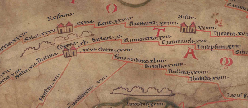 To the image detail |
| Toponym before | XXVI Edessa |
| Toponym following | XXVII Fons Scabore |
| Alternative Image | --- |
| Image (Barrington 2000) |
 |
| Image (Scheyb 1753) | --- |
| Image (Welser 1598) | --- |
| Image (MSI 2025) | --- |
| Pleiades: | https://pleiades.stoa.org/places/658427 |
| Area: | Asia East of Euphrates, South of Taurus Mountains |
| Toponym Type: | Toponym, no Symbol |
| Grid square: | 10B4 |
| Toponym Color: | black |
| Vignette Type : | --- |
| Itinerary: | (192,4 Carris) |
| Alternative Name (Lexica): |
|
| Name A (RE): | Κάρραι - https://elexikon.ch/RE/X,2_2009.png |
| Name B (Barrington Atlas): | Carrhae (67 H3) |
| Name C (TIR/TIB/others): |
|
| Name D (Miller): |
|
| Name E (Levi): |
|
| Name F (Ravennate): |
|
| Name G (Ptolemy): |
|
| Plinius: |
|
| Strabo: |
|
| Dating from Toponym on TP: | --- |
| Argument for Dating: |
|
| Commentary on the Toponym: |
Kommentar (Talbert): |
| References: |
Miller, Itineraria, Sp. 780; |
| Last Update: | 20.08.2025 20:57 |
Cite this page:
https://www1.ku.de/ggf/ag/tabula_peutingeriana/trefferanzeige_en.php?id=1779 [last accessed on June 5, 2026]