deutsch englisch spanisch französisch italienisch
Ausschnitt aus der Tabula Peutingeriana - Rom

Tabula Peutingeriana – Pantalla individual
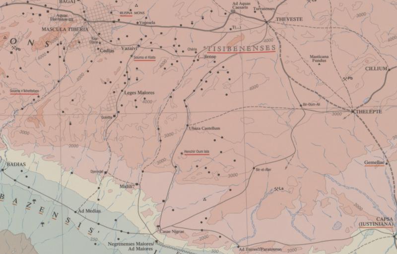
Topónimo (simplificado):

Ubaza Castellum

Nombre (moderno):

Terebaza

Imagen:
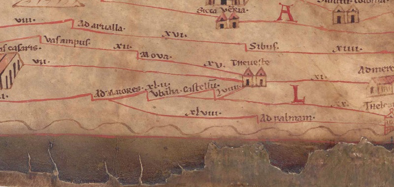
Al detalle de la imagen
Topónimo antes XLII     Ad Maiores     
Topónimo después -     (unnamed / illegible, no. N)     
Imagen alternativa ---
Imagen (Barrington 2000)
Imagen (Scheyb 1753) ---
Imagen (Welser 1598) ---
Imagen (MSI 2025) ---
Pleiades: https://pleiades.stoa.org/places/334653
Área:

Numidia

Tipo de topónimo:

Topónimo sin símbolo

Cuadrícula:

3C4 / 3C5

Color del topónimo:

negro

Tipo de viñeta:

---

Itinerario:


Nombres alternativos (diccionarios):


Nombre A (RE):

Ubaza

Nombre B (Barrington Atlas):

Ubaza Castellum (34 F3)

Nombre C (TIR / TIB /otros):


Nombre D (Miller):

Vbaza. Castellu

Nombre E (Levi):


Nombre F (Ravenate):


Nombre G (Ptolemaios):


Plinius:


Strabo:


Datación del topónimo en la TP:

---

Fundamento para la datación:


Comentario al topónimo:

Kommentar (Talbert):
-> stretch to Theveste
- One stretch is drawn as two.
- The second of these two stretches, while strictly speaking redundant, serves to create added space for insertion of the long distance figure LVIIII; there is no resort to writing LIX. In any event, the copyist could have achieved a potentially less confusing presentation by distancing the downward branch (out of the first stretch) from the second stretch.

Miller, Itineraria, Sp. 923:
[Vbaza. Castellum (Irrig Ubaha (Bt, Bg, Ve)) 59]; j. Terebaza. CIL VIII 2437. 10694, siehe Strecke 132. 20.

Miller, Itineraria, Sp. 931:
Vbaza. Castellu (Strecke 128); j. Terebaza. Abzweigung nach Thelepte (Strecke 128) von hier oder wahrscheinlicher von Theveste aus. 42.

Datierung (Barrington):
Ubaza Castellum – Roman/Late Antique (AAA 39.258)
§ *Turris Ubaza

RE:
Ubaza ON VIII A.1 529 Courtois, C.
Ubaza, Ortschaft in Numidien, heute Terebza oder Terrebaza, worin sich der antike Name Turris Ubaza wiederfindet. U. liegt am rechten Ufer des oued Boua und wird von Tab. Peut. IV 5 unter der Form Ubaza castellu(m) zu Beginn einer Seitenstraße angegeben, die von der Straße Theveste (Tebessa) - ad Maiores (Henchir Besseriani) nach Thelepte (Medinet el-Kedima) führte. Ruine einer Befestigung, St. Gsell Atlas 39, 258. U. war offenbar ein Militärposten mit der Bestimmung, die Bewohner der Berge der Nememchas zu überwachen [Ch. Courtois.]

Bibliografía:

Miller, Itineraria, Sp. 923. 931;

Courtois, Christian, Ubaza, RE VIII A.1, 1955, Sp. 529.

   [Standard-Literatur-Liste im PDF-Format]

Última elaboración:

31.12.2024 01:32


Cite this page:
https://www1.ku.de/ggf/ag/tabula_peutingeriana/trefferanzeige_es.php?id=1239 [zuletzt aufgerufen am 16.08.2025]

Derechos Política de privacidad