
Tabula Peutingeriana – Einzelanzeige
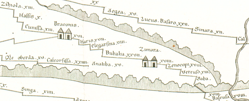
| Toponym TP (aufgelöst): | Bubalia |
| Name (modern): | ??? bei oder in Kuruçay |
| Bild: | 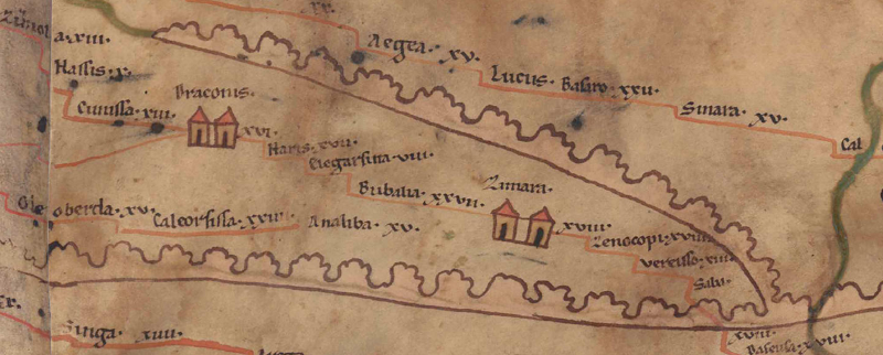 Zum Bildausschnitt auf der gesamten TP |
| Toponym vorher | VIII Elegarsina |
| Toponym nachher | XXVII Zimara |
| Alternatives Bild | --- |
| Bild (Barrington 2000) | --- |
| Bild (Scheyb 1753) |
 |
| Bild (Welser 1598) | --- |
| Bild (MSI 2025) | --- |
| Pleiades: | https://pleiades.stoa.org/places/876599 |
| Großraum: | Asia Minor |
| Toponym Typus: | Ortsname ohne Symbol |
| Planquadrat: | 10B1 |
| Farbe des Toponyms: | schwarz |
| Vignette Typus : | --- |
| Itinerar (ed. Cuntz): |
|
| Alternativer Name (Lexika): |
|
| RE: | Bubalia 1 |
| Barrington Atlas: | Bubalia (89 unlocated) |
| TIR / TIB /sonstiges: |
|
| Miller: | Bubalia |
| Levi: |
|
| Ravennat: |
|
| Ptolemaios (ed. Stückelberger / Grasshoff): |
|
| Plinius: |
|
| Strabo: |
|
| Autor (Hellenismus / Späte Republik): |
|
| Datierung des Toponyms auf der TP: | --- |
| Begründung zur Datierung: |
|
| Kommentar zum Toponym: |
In Wirklichkeit irgendwo (süd)westl. der vorangehenden Station Elegarsina. |
| Literatur: |
Bryer, A. A. M./Winfield, D. C.: The Byzantine monuments and topography of the Pontos, Bd. 1, Washington DC 1985, 32. |
| Letzte Bearbeitung: | 20.09.2025 16:04 |
Cite this page:
https://www1.ku.de/ggf/ag/tabula_peutingeriana/trefferanzeige.php?id=1649 [zuletzt aufgerufen am 26.07.2026]