deutsch englisch spanisch französisch italienisch
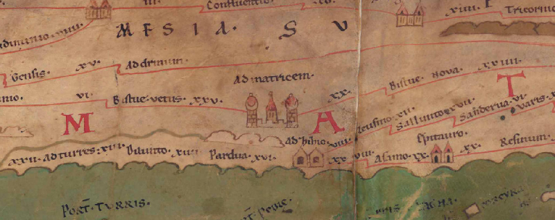
Ausschnitt aus der Tabula Peutingeriana - Rom

Tabula Peutingeriana – Einzelanzeige

Toponym TP (aufgelöst):

Ad Matricem

Name (modern):

Otinovci

Bild:
Zum Bildausschnitt auf der gesamten TP
Toponym vorher XXV     Bistue vetus     
Toponym nachher XX     Bistua nova     
Alternatives Bild ---
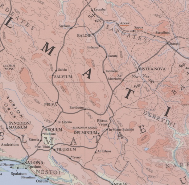
Bild (Barrington 2000)
Bild (Scheyb 1753) ---
Bild (Welser 1598) ---
Bild (MSI 2025) ---
Großraum:

Balkanraum nördlich

Toponym Typus:

Ortsname mit Symbol

Planquadrat:

5A5

Farbe des Toponyms:

schwarz

Vignette Typus :

G Sondervignette

Itinerar (ed. Cuntz):


Alternativer Name (Lexika):


RE:

ad Matricem

Barrington Atlas:

Ad Matricem

TIR / TIB /sonstiges:


Miller:

Ad Matricem

Levi:

Ad matricem (G)

Ravennat:


Ptolemaios (ed. Stückelberger / Grasshoff):


Plinius:


Strabo:


Datierung des Toponyms auf der TP:

frühe Kaiserzeit (einschließlich Flavier)

Begründung zur Datierung:


Kommentar zum Toponym:

Einziger Beleg des Ortsnamens.

Ad Matricem, am Fuß des Vranica-Gebirges gelegen, war wahrscheinlich Zentrum des römischen Bergbaus im Gebiet von Uskoplje und der umliegenden Gebirge mit Gold, Silber- und Erzvorkommen. Der Bestandteil matrix in dem Toponym bezieht sich auf das Verzeichnis der Kolonen, die in den Bergwerken arbeiteten.

Auffällig ist die Vignette mit den Kuppeltürmen, die durch eine Zinnenmauer miteinander verbunden sind, die vielleicht auf die herausgehobene Bedeutung des durch Bergbau reichen Ortes verweist, vielleicht aber auch eine eher dekorative Funktion hat (Gautier-Dalché) und als Produkt der "mera fantasia del copista" (Levi, Itineraria, 94) zu bewerten ist.

Nach Miller (Weltkarte, 92) ist der Ort "sonst unbekannt".

Heute wird der Ort zumeist mit Otinovci bei Kupres identifiziert. Dort Funde eines frühchristlichen Gebäudekomplexes mit Basilika und dekorierten Gräbern (dazu Gudelj 2000).

Weber (Tabula Peutingeriana, 44) identifiziert Ad Matricem mit Bugojano, dagegen Chevalier und Talbert mit Otinovci im Vrbas (Urbanus)-Tal (dort Funde von Grabsteinen CIL III 2763; 13233-13235; 14317-14320, s. ItMiller 473, und eines christlichen Gebäudekomplexes, s. dazu Gudelj 2000). Ältere Lokalisierungstheorien (Gornji Vakuf) s. Petrovič 2013, 264 Anm. 969.

Meilenangabe nach Bistue nova: xx.

Literatur:

Bojanovski, Ivo: Bojanovski, Dolabelin sistem cesta u rimskoj provinciji Dalmaciji / Dolabellae systema viarum in provincia romana Dalmatia, Djela ANUBiH 47, Sarajevo 1974, 167.

Fluss, Max: ad Matricem, RE 14,2 (1930), 2250.

Ante Škegro, Bergbau der römischen Provinz Dalmatien, Zagreb 1998, 17-105, hier 39f. 85;

Ljubomir Gudelj, Ranokršćanski kompleks u Otinovcima na Kupreškoj visoravni. Rezultati revizijskih istraživanja 1999. godine / Early Christian Complex in Otinovci at the Kupres Plateau. Results of the 1999 revision researches, Starohrvatska Prosvjeta 3. Serija, 27 (2000), 95-113;

Patrick Gautier-Dalché, The Medieval and Renaissance Transmission of the Tabula Peutingeria (ital Version benutzen: La trasmissione medievale e rinascimenttale della Tabula Peutingeria, in: Francesco Prontera (Hrg.), Le Antiche Vie del Mondo, Firenze 2003, 43-52;

Tibor Živkovič, The Urban Landscape of Early Medieval Slavic Principalities in the Territories of the Former Praefectura Illyricum and in the Province of Dalmatia (ca. 610-950), in: Ders., The World of the Slavs. Studies on the East, West and South Slavs: Civitas, Oppidas, Villas and Archaeological Evidence (7th to 11th Centuries AD), Belgrade 2013 (= The Institute of History, Monographs 64), 15-35; 32 Anm. 78.

Vladeta Petrovič: Terrestrial Communication in the Late Antiquity and the Early Middle Ages, ebd., 264.


Max Fluss: ad Matricem, RE 14,2 (1930), 2250.
Géza Alföldy, Eine Straßenbauinschrift aus Salona, in: AAASH 16, 1964, 247-256; Ders., Eine Straßenbauinschrift aus Salona, in: Klio 46, 1965, 323-327; Ivo Bojanovski, Dolabelin sistem cesta u rimskoj provinciji Dalmaciji / Dolabellae systema viarum in provincia romana Dalmatia, Sarajevo 1974 (= Djela / Akademija nauka i umjetnosti Bosne i Hercegovine 47), 167; Ante Škegro, Bergbau der römischen Provinz Dalmatien, Zagreb 1998, 17-105, hier 39f. 85; Ljubomir Gudelj, Ranokršćanski kompleks u Otinovcima na Kupreškoj visoravni. Rezultati revizijskih istraživanja 1999. godine. / Early Christian Complex in Otinovci at the Kupres Plateau. Results of the 1999 revision researches, Starohrvatska Prosvjeta 3. Serija, 27 (2000), 95-113; Patrick Gautier-Dalché, The Medieval and Renaissance Transmission of the Tabula Peutingeria (ital Version benutzen: La trasmissione medievale e rinascimenttale della Tabula Peutingeria, in: Francesco Prontera (Hrg.), Le Antiche Vie del Mondo, Firenze 2003, 43-52; Tibor Živkovič, The Urban Landscape of Early Medieval Slavic Principalities in the Territories of the Former Praefectura Illyricum and in the Province of Dalmatia (ca. 610-950), in: Ders., The World of the Slavs. Studies on the East, West and South Slavs: Civitas, Oppidas, Villas and Archaeological Evidence (7th to 11th Centuries AD), Belgrade 2013 (= The Institute of History, Monographs 64), 15-35; 32 Anm. 78. Vladeta Petrovič, Terrestrial Communication in the Late Antiquity and the Early Middle Ages, ebd., 264.

   [Standard-Literatur-Liste im PDF-Format]

Letzte Bearbeitung:

21.08.2023 16:47


Cite this page:
https://www1.ku.de/ggf/ag/tabula_peutingeriana/trefferanzeige.php?id=754 [zuletzt aufgerufen am 30.11.2024]

Impressum Datenschutzerklärung